
Pittsburgh: Rising temperatures ahead of more strong storms
Wednesday is now a Severe Weather Alert Day.
CITIZENSHIP AND A PHOTO ID IN ORDER TO VOTE. RIGHT NOW, WE ARE DEALING WITH ALL CALM AND QUIET CONDITIONS. GOING TO BE A LITTLE BREEZY THIS AFTERNOON WITH SOME SUNSHINE. WARMER AND A BIT ON THE BREEZY SIDE. TUESDAY. SMALL CHANCE FOR A STRAY SHOWER, BUT ALL EYES ON WEDNESDAY. SEVERE WEATHER ALERT DAY AS RAIN WILL BE COMING IN AND POTENTIAL FOR SOME STRONG TO SEVERE THUNDERSTORMS. WE’RE GOING TO TIME THAT OUT HERE JUST A MINUTE OR SO. RIGHT NOW ALL IS CALM AND QUIET. YOU CAN SEE THE PARKWAY EAST HERE IN THE CORNER. LOOKS LIKE TRAFFIC IS MOVING PRETTY SMOOTHLY. LILY WILL HAVE MORE ON THAT HERE IN JUST A MINUTE, BUT WE HAVE A FEW HIGH CLOUDS TRYING TO MIX IN, BUT WE’RE GOING TO HAVE SOME SUN GLARE LATER THIS MORNING AND THROUGH THE DAY. LOTS OF SUNSHINE ON TAP TO KICK OFF OUR WEEK 39. RIGHT NOW IN PITTSBURGH 37 AS YOU WAKE UP IN GREENSBURG, 43 CURRENTLY INTO BUTLER, WASHINGTON AT 41, IN NEW CASTLE AT 42. WINDS ARE GOING TO PICK UP LATER TODAY. YOU’RE GOING TO NOTICE THIS TEN 11:00 AND CONTINUING THROUGH THE EARLY EVENING AROUND A 20 TO 25 MILE PER HOUR WIND GUSTS. SO IT’S GOING TO ADD A LITTLE CHILL TO THE AIR, ESPECIALLY AS WE GET LATE MORNING. BUT WE ARE GOING TO PEAK INTO THE UPPER 60S. GETTING INTO THE LOW 70S TUESDAY AND WEDNESDAY. AND AS THAT STRONG FRONT MOVES THROUGH, BRINGING THE CHANCE FOR STRONG TO SEVERE STORMS. OUR TEMPS DROP SIGNIFICANTLY THURSDAY AND FRIDAY DOWN INTO THE 40S AND 50S, BUT MORE SEASONAL INTO THE WEEKEND. RIGHT NOW, WEEKEND LOOKS TO STAY DRY AND WILL BE INTO THE UPPER 40S AS WELL. SO LET’S TIME OUT OUR TUESDAY WANT TO SHOW YOU THAT CHANCE FOR SOME SPOTTY SHOWERS EVEN INTO THE MORNING. A VERY HIT OR MISS COULD SEE A LITTLE WAVE PASSING SOUTH AND EAST OF PITTSBURGH BEFORE 2:00, BUT OVERALL, I THINK MOST OF US WILL STAY DRY. RELATIVELY QUIET. BUT AS WE GET INTO WEDNESDAY, THAT’S WHEN IT STARTS TO CHANGE. SO WE HAVE BEEN PUT UNDER AN ISOLATED RISK FOR STRONG TO SEVERE STORMS. BIGGEST THREAT AGAIN IS GOING TO BE DAMAGING WINDS AND HEAVY DOWNPOURS. THE TORNADO THREAT IS LOW, BUT WE CANNOT RULE IT OUT. EVEN THE CASE WITH SOME HAIL. AND HERE’S WHY. WE’RE GOING TO SEE THIS LINE DEVELOPING. WE WILL HAVE A LITTLE BIT OF ACTIVITY INTO THE MORNING. AND KEEP IN MIND THIS TIMING STILL COULD CHANGE. WE STILL HAVE A COUPLE DAYS TO GET THERE, BUT THIS LOOKS LIKE AROUND 4 OR 5:00. COULD SEE SOME ACTIVITY UP ALONG I-80, BUT MOST OF US STAYING DRY. SO NORTH OF 422 EARLY MORNING, YOU MAY SEE SOME OF THE HEAVY RAIN AND THUNDERSTORMS. FIRST LITTLE WAVES COMING IN AROUND 11 12:00, WIDELY SCATTERED. IT’S GOING TO CONTINUE TO RAMP UP BEFORE THAT FRONT APPROACHES BY 3:00. COULD REALLY HIT PARTS OF WASHINGTON, WESTMORELAND AND FAYETTE. SOME AREAS THAT GOT HIT PRETTY HARD OVER THE WEEKEND, AND ALSO INTO SOUTHERN PARTS OF ALLEGHENY COUNTY. AS WE CONTINUE THROUGH THE EVENING. STILL AROUND 7:00, IT LOOKS LIKE THE FRONT’S GOING TO GET CLOSER TO US AROUND 530 6:00, SWINGING THROUGH AS IT LOSES THE DAYTIME HEATING. WE’RE ALSO GOING TO SEE IT WEAKEN A LITTLE BIT, BUT OVERALL STILL BY NINE 10:00 AT NIGHT COULD HAVE SOME HEAVY DOWNPOURS SOUTH AND EAST GETTING INTO THURSDAY. YES, YOU SEE SOME SNOW THERE. IT IS GOING TO BE COLD ENOUGH IN THOSE HIGHER ELEVATIONS. PORTIONS OF GARRETT AND SOMERSET COULD SEE A LITTLE BIT OF A MIXING. CAN’T RULE OUT AN EARLY MORNING SHOWER, BUT THE BULK OF IT WILL BE OUT OF HERE. THERE’S YOUR 4-DAY PLUS 4 MORE FORECAST SEVERE WEATHER ALERT DAY FOR US ON WEDNESDAY, WITH STRONG TO SEVERE STORMS DEVELOPING IN THE AFTERNOON AND EVENING. STILL AN EARLY MORNING SHOWER WITH A FEW FLAKES EAST ON THURSDAY. THINGS WILL QUIET DOWN. WILL BE A BIT MORE SEASONAL HEADING INT
Pittsburgh: Rising temperatures ahead of more strong storms
Wednesday is now a Severe Weather Alert Day.

The new week is off to a lovely begin with sunshine and warming temperatures. Wednesday has been upgraded to a Severe Weather Alert Day for as much as an inch of rain and one other spherical of strong afternoon thunderstorms.Back-to-back days of sunshine and warming temperaturesIt is evident and comfortably cool to go out the door this morning. Grab your sun shades with a lot of sunshine on faucet all through the day. Temperatures will climb into the higher 60s to round 70 levels. It shall be a number of levels hotter tomorrow. More clouds and a stray bathe are potential late Tuesday.Severe Weather Alert Day WednesdayWednesday is now a Severe Weather Alert Day for rain at instances and one other spherical of strong thunderstorms. A strong chilly entrance will push as much as an inch of rain and the risk of scattered strong storms. The afternoon and night hours will function the perfect likelihood for thunderstorms. Damaging winds and enormous hail are the first threats.This entrance will dramatically drop temperatures with highs going from the low 70s Wednesday to simply the 40s on Thursday. Early rain showers, even a flurry in spots, are potential Thursday morning.Feeling more like mid-MarchTemperatures pattern more seasonal late subsequent week with highs within the 40s and 50s. The outlook is dry however brisk for the Pittsburgh St. Patrick’s Day parade on Saturday. The chillier sample will prolong into the beginning of subsequent week.TODAY: Pleasant with a lot of sunshine. High: 68°.TONIGHT: Clear and never as chilly. Low: 52°.TUESDAY: Warmer with more clouds late and a stray bathe north. High: 72°, low: 60°.WEDNESDAY – Severe Weather Alert Day: Rain at instances with a number of stronger late-day thunderstorms. High: 71°, low: 36°.THURSDAY: Colder with lingering early morning rain showers. High: 42°, low: 32°.
The new week is off to a lovely begin with sunshine and warming temperatures. Wednesday has been upgraded to a Severe Weather Alert Day for as much as an inch of rain and one other spherical of strong afternoon thunderstorms.
Back-to-back days of sunshine and warming temperatures
It is evident and comfortably cool to go out the door this morning. Grab your sun shades with a lot of sunshine on faucet all through the day. Temperatures will climb into the higher 60s to round 70 levels.

It shall be a number of levels hotter tomorrow. More clouds and a stray bathe are potential late Tuesday.
Severe Weather Alert Day Wednesday
Wednesday is now a Severe Weather Alert Day for rain at instances and one other spherical of strong thunderstorms. A strong chilly entrance will push as much as an inch of rain and the risk of scattered strong storms. The afternoon and night hours will function the perfect likelihood for thunderstorms. Damaging winds and enormous hail are the first threats.
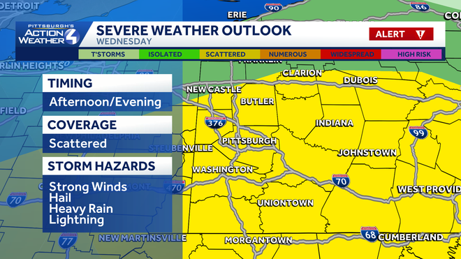
This entrance will dramatically drop temperatures with highs going from the low 70s Wednesday to simply the 40s on Thursday. Early rain showers, even a flurry in spots, are potential Thursday morning.
Feeling more like mid-March
Temperatures pattern more seasonal late subsequent week with highs within the 40s and 50s. The outlook is dry however brisk for the Pittsburgh St. Patrick’s Day parade on Saturday. The chillier sample will prolong into the beginning of subsequent week.
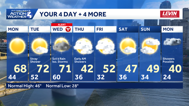
TODAY: Pleasant with a lot of sunshine. High: 68°.
TONIGHT: Clear and never as chilly. Low: 52°.
TUESDAY: Warmer with more clouds late and a stray bathe north. High: 72°, low: 60°.
WEDNESDAY – Severe Weather Alert Day: Rain at instances with a number of stronger late-day thunderstorms. High: 71°, low: 36°.
THURSDAY: Colder with lingering early morning rain showers. High: 42°, low: 32°.


